Choosing between Bhrigu Lake vs Hampta Pass is one of the most common questions I get. Both treks start near Manali, both touch 14,000 feet, and both are rated Moderate — but the experience of walking them is completely different. This guide settles it once and for all.
Bhrigu Lake vs Hampta Pass — if you’re stuck choosing between these two Manali treks, this guide will settle it.
By Jograj, Founder — Trekking Cougars Since 2010
Bhrigu Lake
Hampta Pass
Bhrigu Duration
Hampta Duration
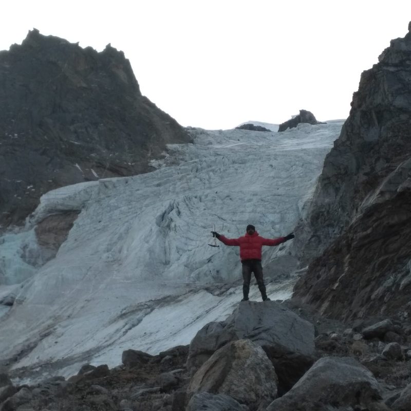
I did Hampta Pass in 2012. Ten, maybe twelve people on the entire trail. Most of them were foreigners — Europeans, a couple of Japanese trekkers. We’d cross paths in the valley, exchange a few words, move on. The Rani Nala was running beside us, the Pir Panjal was overhead, and that particular kind of quiet that only comes when you’re almost alone in a big valley — that was all around us.
That’s what trekking actually is. Being alone in a valley. Being small inside something enormous. That feeling — I’ve spent the last fifteen years trying to give it to people. It’s why we keep looking for different trails, why we run some treks off-season when everyone else has gone home, why we will push back a little when someone just wants a package and a photo. Because that’s not it. That’s not what the mountains are for.
Anyway. Bhrigu Lake versus Hampta Pass. People ask me this constantly and I understand the confusion because on paper they look almost identical — same altitude, same region, same season, both rated Moderate. So let me tell you how they actually differ. Not by the numbers. By what happens to you on each one.
Table of Contents
ToggleBhrigu Lake vs Hampta Pass — the basics first
Both treks start near Manali. Bhrigu Lake goes to 14,009 feet in 4 days, covering 22 km total. Hampta Pass goes to 14,065 feet in 5 days, covering 25–26 km. Bhrigu starts at Gulaba, 24 km from Manali. Hampta starts at Jobra, a bit further. Both are camping treks. Both are best between June and September.
The numbers are close enough that they don’t tell you much. What tells you something is the terrain, the rhythm of each day, and what each trek asks of your body and mind.
| Bhrigu Lake | Hampta Pass | |
|---|---|---|
| Duration | 4 days | 5 days (+1 for Chandratal) |
| Highest Point | 14,009 ft — Bhrigu Lake | 14,065 ft — Hampta Pass |
| Distance | 22 km | 25–26 km |
| Altitude Gain | ~5,480 ft in 2 days | ~5,100 ft over 4 days |
| Campsites | Jonker Thatch (10,285 ft) → Rola Kholi (12,950 ft) | Jwara → Balu Ka Ghera → Shea Goru → Chhatru |
| Trek Type | Return (up and back) | Crossover — Kullu to Lahaul |
| Pass Crossing Day | No pass — lake summit | Yes — 9 hours, the hardest day |
| AMS Risk | Moderate — easy exit if needed | Higher — notorious for AMS, harder exit |
What Bhrigu Lake actually is
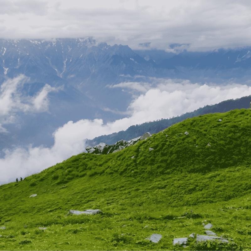
Bhrigu Lake surprises you on the very first day. Most Himalayan treks make you wait — two, three days of forest before any open ground. Bhrigu doesn’t do that. You drive 24 km from Manali to Gulaba, step off the vehicle at 8,530 feet, and within ten minutes of walking the trees open and you’re already in rolling alpine meadow. Not approaching it. In it.
And the meadows on this trek — I want to talk about them because they’re genuinely extraordinary. Indiahikes, who’ve sent more people on both these treks than anyone in India, say explicitly that Bhrigu Lake’s wildflowers outdo Hampta Pass. I’ve done Bhrigu twice. I’d agree with that. In July and August there are sections of this trail where the ground looks like someone scattered paint across it. It rains sometimes, the clouds sit low on the valley, and somehow that makes it better, not worse. Rain in the mountains doesn’t ruin the trek. It’s part of it.
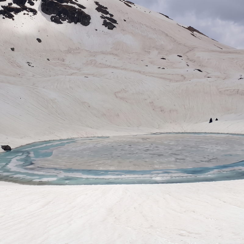
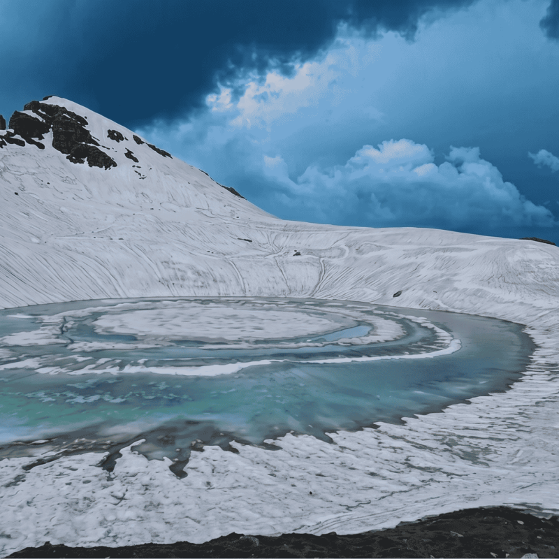
Day 1 camp is Jonker Thatch at 10,285 feet — a sloping meadow, open sky, the Kullu Valley visible below you. Day 2 climbs to Rola Kholi at 12,950 feet, which is one of the finer campsites in the Manali region. At that altitude with the Pir Panjal and Dhauladhar ranges sitting around you in a full arc, you understand why people leave cities for this. Day 3 is the summit push — 5 km to the lake and back, gaining over 1,000 feet more to 14,009 feet. The final section steepens, the air thins, and then the lake appears. Oval, quiet, blue in August. Deo Tibba and Hanuman Tibba behind it.
Both times I’ve been there, people went quiet when they saw it. Not tired-quiet. Struck-quiet. There’s a difference.
One more thing worth knowing: if something goes wrong on Bhrigu — altitude sickness, someone struggling — the exit is easy. You can get someone back to Manali in under a day. That matters. Remember it when you’re deciding.
What Hampta Pass actually is — and what it was in 2012
When I did Hampta Pass in 2012 there was almost nobody there. Ten, twelve people total on a route that now sees hundreds in peak season. I remember the Rani Nala valley on Day 2 as just ours — the river, the boulders, the mountains pressing in, and silence except for the water. That’s the version of this trek I carry with me. That’s the one I want people to feel.
It’s more crowded now. But the mountains haven’t changed. And if you go in September, or in early June before the school holidays arrive, you can still find something close to that.
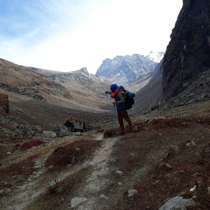
The trek starts at Jobra at 8,965 feet, deeper into the mountains than Gulaba. Day 1 is forested and gentle. Day 2 opens into the valley and you reach Balu Ka Ghera at 12,220 feet — a wide glacial cirque with snow walls around it and the Rani Nala running through the middle. This campsite feels remote in a way Rola Kholi doesn’t. More raw. You can feel the pass from here.
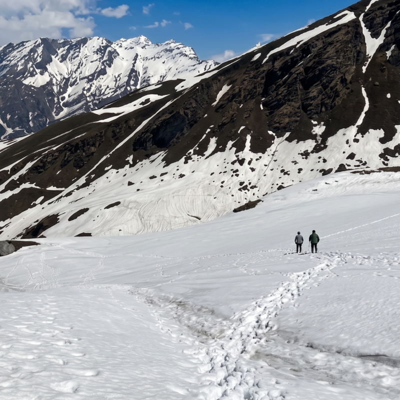
Day 3 is the crossing. Nine hours. You start at 5:30 AM. On the way up, you cross the Rani Nala at Jwara and later the Hampta Nala near Shea Goru — both glacial streams, both cold enough to remind you exactly what you’re doing. In June, heavy snow covers the upper trail from Balu Ka Ghera onward. In August, it’s rock and scree and thin air. The climb demands everything from you in the last section before the pass. And then you’re at the pass.
This is what I keep trying to describe and can’t quite get right. On one side of that pass is the Kullu Valley — green, alive, trees, wildflowers, colour. You take one step through. And Lahaul is on the other side. Brown. Completely bare. Rocky ridges, no vegetation, cold desert stretching away in every direction. Same sky. Completely different planet. I’ve crossed that pass three times and it still surprises me that such a contrast exists in a single step. There’s nothing else like it in Himachal.
The descent to Shea Goru is steep and loose-footed. By Chhatru you’re in Lahaul and the world is brown and quiet and stark. If you add Chandratal on Day 6 — a crescent lake at 14,026 feet in the Lahaul-Spiti district — do it. I’ve never met anyone who regretted adding it.
About the crowds — and why it matters less than you think
People talk about the best season for these treks like there’s one right answer. July for flowers, September for clear skies. But I think the mountains are beautiful any time you go. Brown grass and dry ridges have a beauty that’s just as real — it’s a different kind, that’s all. Depends how you feel it.
What crowds do is put a layer between you and the place. That’s the only thing they take from you. Go in October when the season is ending and most operators have shut down. Go in June before the families arrive. You’ll find something quieter and it will feel more like the thing I experienced in 2012 — being in a valley, being small inside it, nobody around. That’s trekking. The rest is tourism dressed in trekking clothes.
We run Trekking Cougars batches deliberately off the peak windows for exactly this reason. Not always possible, clients have leave constraints, I understand. But when someone gives me flexibility on dates, that’s what I use it for.
The one thing about Hampta that’s undersaid
Hampta Pass has a known altitude sickness problem. Not a secret, but people don’t take it seriously enough. Indiahikes — and they’ve documented this through a real HAPE case study on this route — call Hampta Pass “notorious for AMS cases.” The reason is structural: you start above 8,965 feet at Jobra and you’re at the pass in two more days. That’s a rapid ascent. Your body doesn’t have much time.
On Bhrigu Lake, if someone starts showing symptoms, we can get them down to Manali in a few hours. On Hampta, if you’re at Balu Ka Ghera or already past the pass — the exit is not simple. You have to walk out. That asymmetry is why I always say do Bhrigu first if this is your first time at altitude. Not because it’s easier exactly, but because the consequences of struggling are more manageable.
Indiahikes says the fitness benchmark for Hampta Pass is being able to run 5 km in 35 minutes. That’s not a casual target. If you’re not there, prepare more before you book.
My honest suggestion: do Bhrigu Lake first, Hampta Pass the following year. Not because Bhrigu is lesser — it isn’t. But because you’ll get 30% more out of Hampta if you already know what your body does above 12,000 feet. The pass crossing will hit you differently when you’re not also managing altitude for the first time. You’ll actually be there, instead of just getting through it.
So which one for you?
Bhrigu Lake gives you a lake. A specific, beautiful, high-altitude lake — and the meadow experience of getting there. It’s honest. What it promises is what it delivers. It’s also forgiving in the ways that matter for a first experience at altitude.
Hampta Pass gives you a crossing. A before and after. You walk into one world and emerge from another. The pass moment is the kind of thing you remember for years — not because it’s beautiful in the way a lake is beautiful, but because it’s genuinely surprising. No photograph fully prepares you for standing at 14,065 feet with green Kashmir on one side and brown Lahaul on the other. It’s a different category of feeling.
If you want to arrive somewhere — go to Bhrigu Lake. If you want to cross something — do Hampta Pass.
Both are worth doing. Both are worth doing more than once. I’m still finding things I missed on Bhrigu from my first trip — you only have so much attention when you’re also figuring out how to walk at that altitude. Second time is different. Third time more so. The mountains don’t change. You do. And that’s kind of the point.
If you’re still genuinely stuck — message me. Tell me how many treks you’ve done and how much leave you have. I’ll tell you which one makes sense. And I’ll tell you straight, not because I want to sell you a package, but because sending someone on the wrong trek helps nobody.
Some questions people usually ask
+
+
+
+
+
+